Contents
Share
In order to achieve carbon neutrality, it is essential to accurately calculate the emissions of carbon dioxide (CO2) and the CO2 absorption by forests. In this regard, we interviewed Associate Professor Akira Kato from the Graduate School of Horticultural Science, who shared insights on precise methods for measuring forests and discussed the uniqueness of his award-winning research, including the Chiba University Award for Distinguished Researcher.
Measuring forests’ precisely’ in 3D to attain carbon neutrality
―You are conducting research to “accurately” measure forest and tree data. Please explain the reason for your emphasis on accuracy.
In pursuit of carbon neutrality by 2050, there is a growing demand for “proactive measures” that involve embracing new technologies, such as innovative methods for capturing carbon dioxide from the atmosphere. With their remarkable ability to absorb emitted CO2 and store it as carbon, forests hold a pivotal role in achieving carbon neutrality. However, in Japan, forests have traditionally been seen as sources of timber resources. Moving forward, it is crucial to shift our perspective and acknowledge the diverse ecosystem services* that forests provide. This necessitates reevaluating and enhancing measurement methods to ensure a comprehensive evaluation of forests.
*The wide range of benefits that humans receive from natural ecosystems.
However, due to the vastness of forests and the inability to grasp the complete picture, the estimation of CO2 absorption in forested areas has been largely theoretical. In response, I have proposed a method that enables more precise measurements based on evidence. My work focuses on accurately measuring forest resources, clearly demonstrating the value of forests to the world, and promoting conservation. Essentially, my role entails implementing “defensive measures” that can be realized by preserving existing forests.
―How did you manage to obtain accurate data?
When I started my research 20 years ago, we relied on satellite images for monitoring forests. However, these images only provided information on the visible part from above, which is the canopy (the part covered with leaves). Unfortunately, the majority of CO2 absorption and carbon storage occurs in the trunks. Consequently, it became necessary to obtain accurate measurements of tree trunks.
In recent years, advancements in remote sensing technology have made it possible to easily acquire precise 3D data using lasers, regardless of the complexity of a tree’s structure.
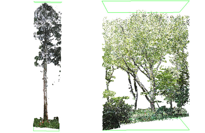
However, there was no one capable of accurately analyzing 3D data. Since tree trunks are not perfect circles, previous analysis approximated them as circles, resulting in significant errors. Recognizing this issue, I focused on developing a technology that can accurately measure the volume of even distorted trunks. This unique capability has led to offers for collaborative research from institutions worldwide.
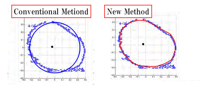
The new method (right) calculates the cross-sectional area from the dot-mapped data as it is and obtains accurate data without the need for tree felling.
Proprietary technology derived from a multidisciplinary approach
―Why were you able to succeed in developing a measurement technology that no one else could achieve?
The key factor was obtaining perspectives from different fields. In 2003, I enrolled in the Department of Forestry at the University of Washington to explore ways to easily determine the volume of tree canopies. The methods used at the time were very complex, relying on numerous formulas.
Unable to find a breakthrough with my knowledge alone, I sought advice from a mathematics professor conducting research using numerical simulations. I was then recommended to try a method called neural networks, combining mathematics and computer graphics.
Taking undergraduate mathematics and computer graphics courses was crucial for understanding the content. The Department of Computer Science at the University of Washington, supported by organizations like Microsoft, is a top-tier academic institution. Despite being surrounded by exceptional IT students, I studied tirelessly to catch up with the programming level.
It was extremely rare for a student from the field of forestry to enroll in these courses. However, thanks to the openness of the American education system, which accepts students from diverse backgrounds regardless of their fields, I was able to develop a technology that can accurately measure any complex shape—an achievement that was the first of its kind in the world. The realization that anything is possible with passion holds great significance in my life.
―Forest researchers who studied computer graphics 15 years ago were likely scarce. How was it applied in your research?
I conceived a completely new idea of adding another dimension to the 3D data to create a boundary surface, representing the intricate surface shape of the forest. While this method is commonly used in mathematical simulations, it is an approach I would not have considered if I had not encountered my mathematics teacher.
In the world of research, there are numerous instances where problems that cannot be solved by looking at them from the same perspective as others in the same field can be resolved vividly by adopting different perspectives from diverse fields. Through this firsthand experience, I have learned the importance of having a cross-sectional view.
―It seems like everything has been going very smoothly, but have you faced any challenges?
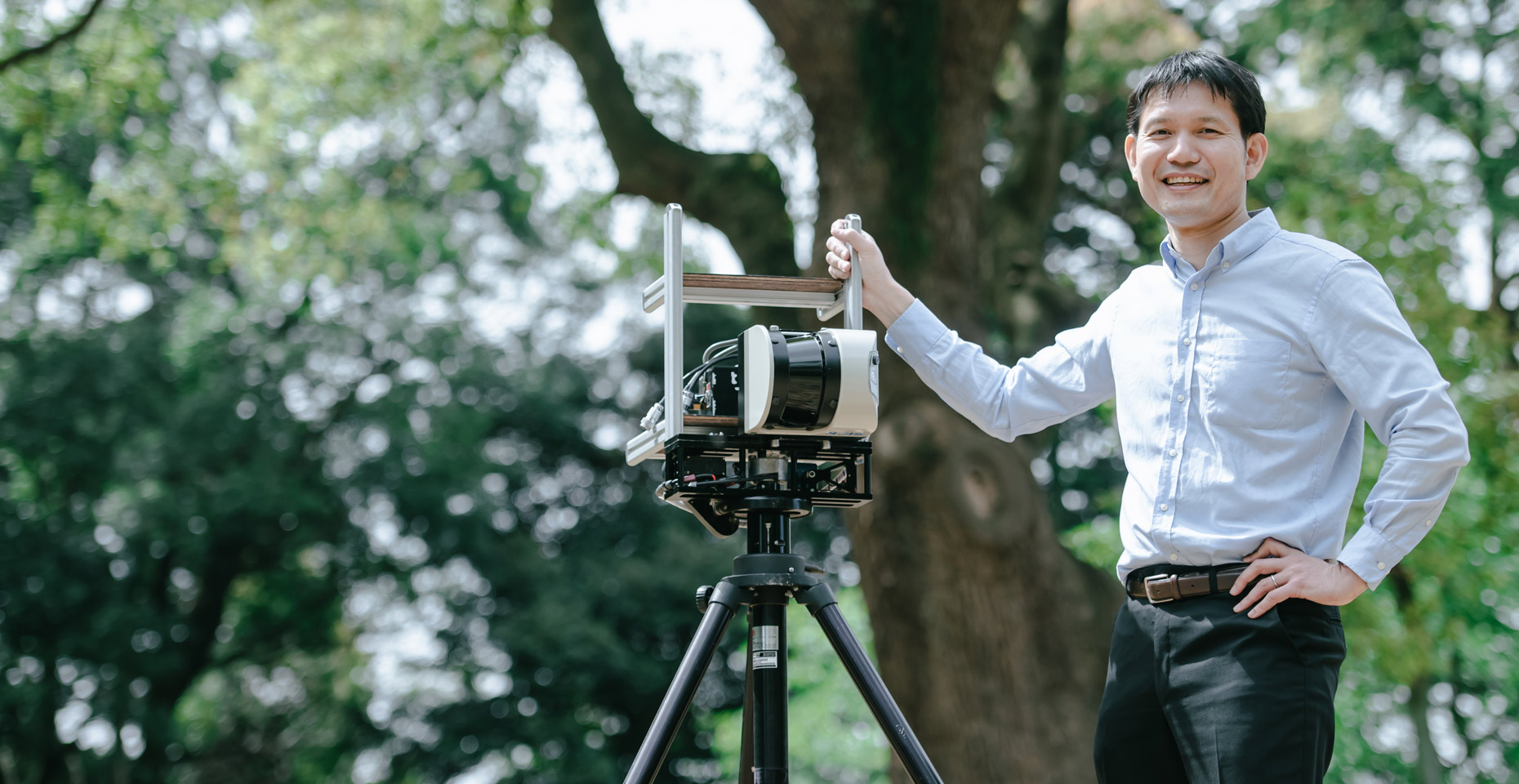
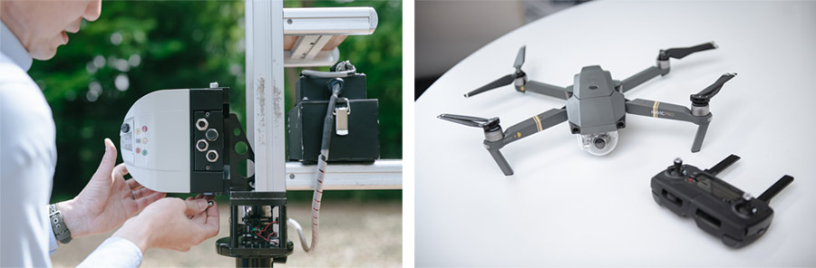
Until recently, 3D data sensors were so expensive that they cost 10 million yen per unit, making it challenging to conduct field surveys easily. This became a bottleneck in my research. To address this issue, the Center for Environmental Remote Sensing at Chiba University developed a sensor equipped with a user-friendly terrestrial laser at a low cost, enabling the acquisition of a large amount of data. The introduction of this “Made in Chiba University” sensor became the breakthrough in my research.
Investigating the underlying causes of forest fires through forest ecology
―Regarding the recent phenomena related to forests, the occurrence of large-scale forest fires is a matter of great concern.
When forests are destroyed by fire, there is a significant loss in carbon sequestration, necessitating recalculation. Therefore, in collaboration with the U.S. Forest Service, I am conducting a project to calculate the area and biomass* lost due to forest fires using analysis based on 3D data.
The concept of quantifying the biological resources (bio) amount (mass). It represents organic resources derived from renewable energy and substances generated by animals and plants (in this case, referring to forests).
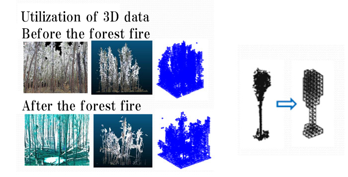
While there are reports linking large-scale forest fires to climate change, analysis of satellite images from the past 30 to 40 years reveals that the natural renewal cycle of forests incorporates forest disturbances, including forest fires.
Once forests reach a certain size, they naturally undergo fires caused by spontaneous combustion, allowing new vegetation to regenerate and sustain a thriving forest. However, as urban development progresses, fires are suppressed in forested areas surrounding residential areas, disrupting the natural fire cycle. This leads to an unnatural accumulation of dense vegetation, creating conditions in forests that are more susceptible to large-scale fires.
You require a forest management approach that aligns with the natural cycle
Appropriate protection and maintenance of forests are essential from disaster prevention and resource management perspectives. In today’s society, where CO2 emissions are traded, the value of forests is being reassessed as land that absorbs CO2, beyond being mere wood resources. Japanese companies are also actively investing in forests, highlighting the need for comprehensive forest management and accurate measurement to demonstrate their true value.
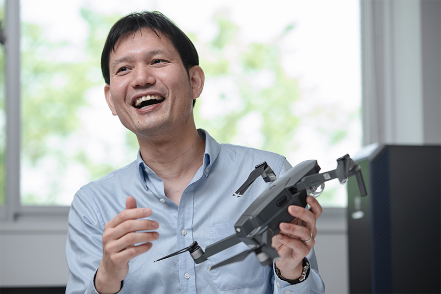
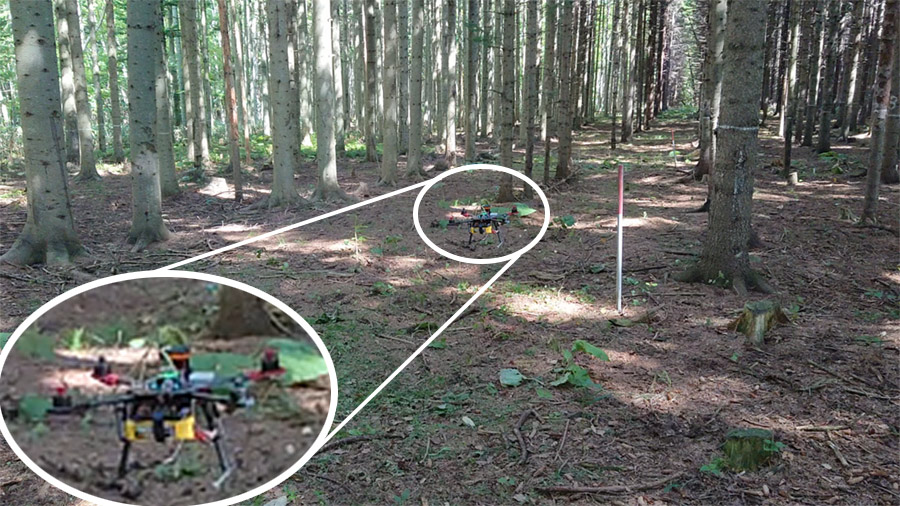
However, the question arises: Who will take care of the forests? Aging populations and labor shortages are significant challenges in forestry. To address this issue, I explored using self-propelled drones capable of automatically measuring forests without human control. By reducing reliance on human labor, I aim to prevent the abandonment of forests. This idea received the Agribusiness Award at the 20th Venture Cup CHIBA, organized by the Chiba City Industrial Promotion Foundation.
In collaboration with Associate Professor Satoshi Suzuki of the Center for Aerial Intelligent Vehicles, Chiba University, I am developing drones capable of autonomous forest traversal without GPS. Through this technology, I am also advancing a project to create a system that can automatically measure the “health condition of forests” across Japan.
―What can we do to protect trees and forests?
Street trees are also vital. They play a significant role in mitigating urban heat, purifying the air, preventing erosion, and offering peace of mind. Recognizing that we benefit from the ecosystem services provided by the trees around us is the first step toward tree conservation.
There is also an app called i-Tree that allows easy evaluation of various functions of street trees. In New York, citizens take the initiative in measuring trees throughout the state using i-Tree, and individual data on roadside trees is published on the web. By utilizing 3D data acquisition technology, such as equipping laser sensors on wheelchairs to collect data on roadside trees, we may be able to create an inclusive society where everyone can participate through tree measurement. I am developing new technologies while Observing trees, aiming to bring us closer to an ideal future.
Series
The Role of Universities to Achieve Carbon Neutrality
What role should universities play in realizing carbon neutrality by 2050? This series will explore this question, accompanied by research conducted at Chiba University.
-
#1
2023.06.22
Harnessing CO2 with a Photocatalyst for Fuel and Plastic Feedstocks: Advancing a Sustainable Society with Chemistry
-

#2
2023.06.29
Unlocking Untapped Urban Resources: Driving Carbon Neutrality through Life Cycle Assessment
-

#3
2023.07.04
Predicting Future CO2 Absorption and Emissions in Terrestrial Ecosystems: International Geostationary Meteorological Satellite Network for Accurate Estimation
-
#4
2023.07.12
The Global Goal of Carbon Neutrality by 2050 (Part 1): Universities as Agents of Change
-

#5
2023.07.14
The Global Goal of Carbon Neutrality by 2050 (Part 2): A decarbonized society from a local perspective
-
#6
2023.09.12
Reassessing the role of “Forest Resources” in achieving carbon neutrality: Measuring forests with the combination of drones, mathematics, and computer graphics
-

#7
2023.09.28
Navigating Offshore Wind Power Expansion: Nurturing Ocean-based Wind Energy Management Experts through Industry-Academia Partnership