


Contents
Share
Researchers develop an AI-based spatial framework to identify where vertical greenery is most needed in Tokyo’s high-density neighborhoods
As cities grow denser and hotter, creating space for greenery becomes increasingly difficult. To address this challenge, researchers from Chiba University developed a data-driven framework that integrates artificial intelligence and spatial analysis to map vertical greenery across Tokyo’s 23 wards. By analyzing over 80,000 street-view images, the team identified uneven distribution patterns and proposed a vertical greening demand index to guide future urban greening initiatives and climate-resilient urban planning.
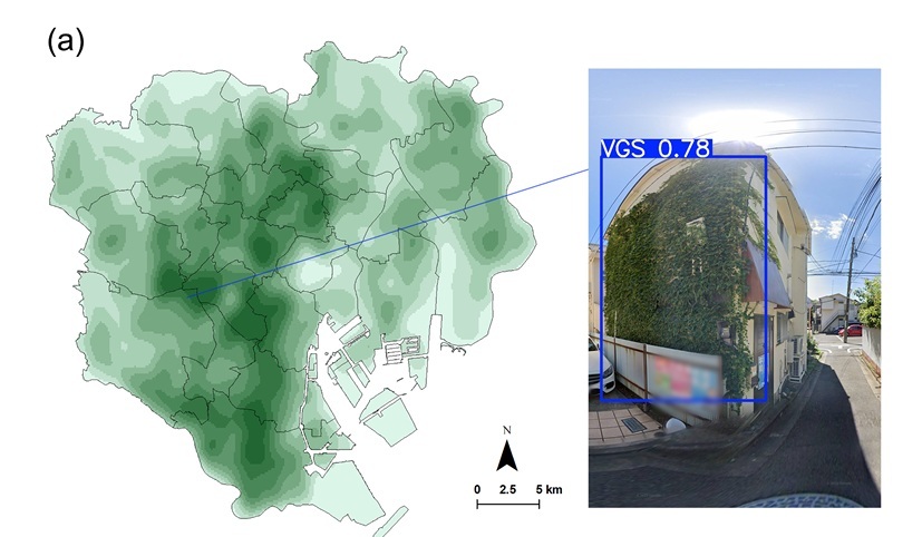
Image title: Mapping vertical greening across Tokyo’s 23 wards
Image caption: Researchers from Chiba University analyzed over 80,000 street-view images to map vertical greenery in Tokyo, revealing that green façades are much more prevalent than living walls. The study also identified areas where additional greenery could improve urban comfort, mitigate heat, and enhance overall city life.
Image credit & source link: Professor Katsunori Furuya from Chiba University, Japan
https://www.sciencedirect.com/science/article/pii/S2210670725006729
Image license: CC BY-NC-ND 4.0
Usage Restrictions: Credit must be given to the creator. Only non-commercial uses of the work are permitted. No derivatives or adaptations of the work are permitted.
In rapidly growing cities like Tokyo, incorporating greenery is a challenging task. With limited space for trees or parks, vertical greening—the placement of vegetation on building façades—has become a creative solution to reintroduce nature into crowded urban settings. However, until now, there has been no clear method to assess where this type of greenery is most needed or most effective.
To address this challenge, researchers from Chiba University in Japan have created a data-driven spatial framework that identifies the best locations for vertical greening throughout Tokyo’s 23 wards. The study, made available online on September 6, 2025, and published in Volume 132 of the journal Sustainable Cities and Society on September 15, 2025, provides the first citywide map of vertical greenery in one of the world’s densest metropolitan areas.
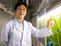
The research team—led by Professor Katsunori Furuya, along with Ms. Ruochen Ma, Ms. Yunchen Xu, Ms. Yan Tang, Mr. Sihan Zhang, and Ms. Yuhui Liao from the Graduate School of Horticulture, Chiba University, Japan—used artificial intelligence to analyze more than 80,000 Google Street View images. Using a deep-learning model (YOLOv8), they detected façades featuring vegetation, such as green walls and balcony plants, to create a detailed spatial inventory of Tokyo’s vertical greening systems.
“With this study, we aimed to provide a clearer picture of how vertical greenery is distributed in dense urban areas like Tokyo and how it aligns—or fails to align—with environmental needs,” explains Prof. Furuya. “By combining AI-based image analysis with spatial data, we can now pinpoint where greening efforts could make the greatest difference.”
The researchers introduced a new metric called the vertical greening demand index (VGDI), which evaluates where additional greening could reduce urban heat most effectively and improve environmental quality. The VGDI integrates multiple factors, such as land use, building density, surface temperature, and pedestrian exposure to heat.
Their findings revealed an uneven distribution of vertical greenery across the city. While commercial and residential zones in central Tokyo had some vegetated façades, several heat-prone and lower-income neighborhoods had far less greenery, highlighting the need for a more equitable distribution. The team also identified “priority greening zones,” where adding vertical vegetation could reduce surface temperatures and improve thermal comfort for residents.
“Our analysis shows that vertical greening is not just an architectural feature—it’s an environmental necessity,” says Prof.Furuya. “With data-driven planning, city authorities can target specific areas to enhance cooling, biodiversity, and overall urban resilience.”
The framework’s implications extend beyond Tokyo. As compact cities around the world face rising temperatures and limited ground space, similar data-driven tools can guide the selection of sites for vertical greening to achieve maximum benefit. Policymakers can use indices like the VGDI to inform building regulations, urban renewal projects, and greening incentive programs.
In the long run, such approaches could reshape how cities address the growing challenges of climate change. “Expanding greenery within existing built environments is one of the most urgent urban challenges today,” adds Prof. Furuya. “Over the next decade, combining AI and spatial analysis will help governments and designers plan greener, cooler, and more livable cities.”
The study also highlights the importance of accessibility and fairness in urban environmental planning. By visualizing where greenery is lacking, the framework allows for more transparent and equitable decision-making. As cities worldwide strive toward sustainability goals, data-driven tools like this can help ensure that the benefits of urban greening reach all residents—not just those in wealthier districts.
Overall, this work marks an important step toward integrating artificial intelligence with urban ecology and planning. In the future, researchers hope to refine the model by including more environmental parameters, such as air quality and energy savings, and extending it to other megacities that face similar urban heat challenges.
To see more news from Chiba University, visit https://www.cn.chiba-u.jp/en/news/
About Professor Katsunori Furuya from Chiba University, Japan
Dr. Katsunori Furuya is a Professor in Landscape Planning at the Graduate School of Horticulture, Chiba University, Japan. He earned his Bachelor of Agriculture in Landscape Architecture in 1985, Master of Agriculture in Landscape Architecture in 1988, and Ph.D. in Environmental Planning in 1991—all from Chiba University. His research focuses on nature conservation, landscape planning and architecture, environmental education, urban green space, ecotourism, and public participation. He has published over 200 peer-reviewed papers and 14 books, with more than 1,000 citations. Among his distinctions are the Japanese Institute of Landscape Architecture Award and Chiba University’s Best Teacher Award.
Funding:
This work was supported by the Japan Science and Technology Agency (Grant Number JPMJSP2109) and the Japan Society for the Promotion of Science (JSPS) KAKENHI, Grant-in-Aid for Scientific Research (B) (Grant Number 24K03144).
Reference:
Title of original paper: Development of a data-driven spatial framework for optimizing vertical greening in high-density Tokyo
Authors: Ruochen Ma, Yunchen Xu, Yan Tang, Sihan Zhang, Yuhui Liao, and Katsunori Furuya
Affiliations: Graduate School of Horticulture, Chiba University, Japan
Journal: Sustainable Cities and Society
DOI: 10.1016/j.scs.2025.106798
Contact: Katsunori Furuya
Graduate School of Horticulture, Chiba University, Japan
Email: k.furuya@faculty.chiba-u.jp
Academic Research & Innovation Management Organization (IMO), Chiba University
Address: 1-33 Yayoi, Inage, Chiba 263-8522, Japan
Email: cn-info@chiba-u.jp