Contents
Share
Researchers compare the new monitoring technique with existing observation well systems and global navigation systems
Land subsidence causes Earth’s surface to sink, flooding coastal areas and damaging infrastructure. It can be monitored using observation wells, global navigation satellite systems (GNSS), and interferometric synthetic aperture radar (InSAR). Given its accuracy and applicability, researchers have recently utilized consecutive differential InSAR to investigate subsidence in the Kanagawa prefecture in Japan. The results were consistent with observation well and GNSS data, indicating its potential for substituting other monitoring techniques.
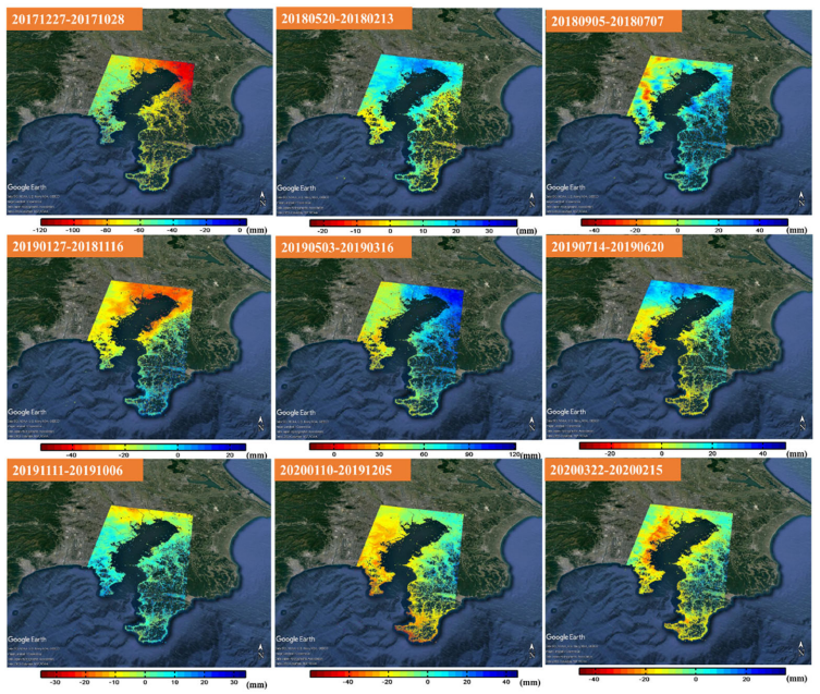
Title: Analyzed satellite images depicting land surface displacement in Kanagawa prefecture in Japan
Image caption: Researchers analyzed the images acquired by the European Space Agency satellite program Sentinel 1 using SARPROZ software, which implements DInSAR land subsidence monitoring technique
Image credit: Katsunoshin Nishi of the Graduate School of Science and Engineering at Chiba University
License type: CC-BY-4.0
Usage restrictions: Open Access
Land subsidence is a phenomenon wherein the Earth’s surface sinks downwards. It occurs mainly due to human activities, such as excessive groundwater extraction. It is a major global concern, affecting 19% of the world’s population. In Japan, some parts of the Tokyo metropolitan region are already sinking. This process can accelerate the flooding of coastal areas and cause damage to buildings and infrastructure. Therefore, monitoring land subsidence is crucial.
In Japan, observation wells are utilized to measure changes in the land surface and groundwater levels every few months. Additionally, the global navigation satellite system (GNSS) is also popular. However, observation wells are more reliable because atmospheric effects can modify GNSS observations. Observation wells require regular maintenance of their machines, which is expensive. Further, there is an anticipated shortage of engineers qualified to undertake the job as the Japanese population gets older with a declining birth rate. In this light, a new land subsidence monitoring technique—interferometric synthetic aperture radar (InSAR)—is gaining attention.
Recently, Katsunoshin Nishi, a Ph.D. student at the Graduate School of Science and Engineering at Chiba University, Japan, along with a group of researchers, applied consecutive differential InSAR (DInSAR) to investigate land subsidence in Yokohama, Yokosuka, and Miura cities of Kanagawa prefecture in Japan. They compared the results obtained with those of other monitoring techniques. Their work was published in Volume 38, Issue 1 of the Geocarto International journal on 28 December 2022.
“InSAR is a remote sensing technique that uses two satellite SAR images to measure surface elevation. It exploits the phase of the satellite signal waves for the purpose. Going a step further, Consecutive DInSAR can measure millimeter changes in the elevation in time series, thus detecting land subsidence. It is quantified in terms of subsidence rate or land surface velocity,” explains Mr. Nishi. The work also involved contributions from Masaaki Kawai from Mitsubishi Heavy Industries Ltd, Japan, Bowo Eko Cahyono from the University of Jember, Indonesia, Mirza Muhammad Waqard from Lumir Inc, Korea, Kaori Nishi from Bella Earther, Japan and Josaphat Tetuko Sri Sumantyo Chiba University, Japan and Universitas Sebelas Maret, Indonesia.
In their study, the researchers analyzed the images acquired by Sentinel 1 European Space Agency satellite program—from August 2017 to March 2022 using SARPROZ software, which implements DInSAR. In addition, they also formulated a new computation model called “the law of material conservation.” It uses surface pressure values to calculate groundwater level and the amount and cause of land subsidence.
The researchers found that Consecutive DInSAR results were consistent with both observation well and GNSS data. Its mean subsidence rate of 1.58 cm/year was respectively within 0.02 cm/year and 0.90 cm/year of their corresponding values. Also, its mean Root Mean Square Error (RMSE) was respectively 0.39 cm/year and 0.46 cm/year of their corresponding values. Further, the land subsidence mechanisms could be accurately identified through the proposed law.
In conclusion, Mr. Nishi highlights the long-term potential of the new monitoring technique. “By utilizing Consecutive DInSAR and satellite data, the government can take effective and timely measures to tackle land subsidence. Further, determining the extent and cause of land subsidence will enable the administration to set land subsidence thresholds and limit groundwater use. Consequently, people in coastal regions or previously-land subsided areas can live safely and securely.”
Overall, Consecutive DInSAR can potentially substitute the land subsidence observation well technique in future.
About Mr. Katsunoshin Nishi from Chiba University, Japan
Katsunoshin Nishi is a Ph.D. student at the Graduate School of Science and Engineering of Chiba University in Japan. He worked on space policy making at the Ministry of Internal Affairs and Communications and the Ministry of Foreign Affairs, Japan, and worked to solve global environmental problems. He has published nine research articles and worked on multiple projects in collaboration with other researchers. His primary research interests include the Consecutive DInSAR monitoring technique, land subsidence, local revitalization, public policy, and remote sensing. His work significantly contributes to the United Nations’ Sustainable Development Goals.
Reference
Title of original paper:
Consecutive DInSAR and well based on the law of material conservation between land surface pressure and ground water to observe land subsidence
Authors: Katsunoshin Nishi1, Masaaki Kawai2 , Bowo Eko Cahyono3, Mirza Muhammad Waqar4, Kaori Nishi5, and Josaphat Tetuko Sri Sumantyo1,6
Affiliations:
- Graduate School of Science and Engineering, Chiba University
- Digital Innovation Headquarters, Mitsubishi Heavy Industries Ltd
- Mathematics and Natural Science Faculty, University of Jember
- SAR Application Division, Lumir Inc
- Research Innovation Center, Bella Earther
- Center of Environmental Remote Sensing (CEReS), Chiba University and Department of Electrical Engineering, Universitas Sebelas Maret
DOI: 10.1080/10106049.2022.2159069
Contact
Katsunoshin Nishi
Graduate School of Science and Engineering, Chiba University
Address: 1-33 Yayoi, Inage, Chiba 263-8522 JAPAN
mail:
K.nishi@chiba-u.jp, katsunoshin.nishi@gmail.com
Josaphat Tetuko Sri Sumantyo
jtetukoss@faculty.chiba-u.jp
Public Relations Office, Chiba University
Address: 1-33 Yayoi, Inage, Chiba 263-8522, JAPAN
Email: koho-press@chiba-u.jp
Recommend
-
Unfettered thinking, elaborate theorizing, and an accepting and positive attitude: With the precepts of his former supervisors in mind, Dr. Shimada is tackling the global food crisis
2023.01.04
-

Enigmatic Soliton Waves in Nature and Space: Demystifying Equations of Everyday Physical Phenomena
2023.12.04
-
CUTICULA: A Secret of Unique Body Shape of Insects −Exploring the Sophisticated Mechanism Behind their Elongated and Round Bodies
2023.12.11